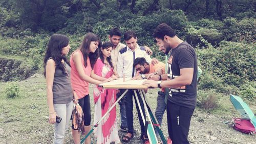
Plane table surveying is one of the fastest and simplest methods of surveying. In this method, field observations and plotting of plans are carried out simultaneously. This reduces office work and saves time. Plane table surveying is particularly useful in the following situations:
- It is best suited for small-scale surveys, such as surveying small fields and plots.
- It is useful in industrial areas where compass surveying fails due to local magnetic disturbances.
- It is commonly used to fill in details between stations already fixed by triangulation or theodolite traversing.
Temporary Adjustments of the Plane Table
Temporary adjustments are essential before starting plane table surveying. These adjustments ensure the accuracy and reliability of the plotted details. The temporary adjustments of a plane table include centering, leveling, and orientation.
1. Centering
Centering is the process of ensuring that the point on the ground is accurately represented on the drawing sheet. It is carried out using a plumbing fork and a plumb bob. The pointed end of the plumbing fork is placed on the plotted point on paper, and the plumb bob is suspended from the other end. The plane table is shifted manually until the plumb bob hangs exactly over the ground station peg. Although this process is time-consuming, it is essential for accurate surveying.
2. Leveling
Leveling is done to keep the drawing board horizontal and parallel to the ground surface. Proper leveling ensures the correct plotting of angles and distances. Leveling of the plane table can be carried out by the following methods:
- By ordinary tilting of the board
- By using a ball and socket arrangement
- By adjusting the legs of the tripod
3. Orientation
Orientation is the process of keeping the plane table at different stations parallel to its previous position. During plane table surveying, the table is moved from one station to another. If proper orientation is not maintained, the plotted lines will not correctly represent the ground features. Therefore, orientation is a very important step. The methods of orientation are described below:
- Orientation by Magnetic Needle:
This method is adopted when it is not possible to sight the previous station from the new station. It is a less reliable method because it is affected by local magnetic attraction and other errors. - Orientation by Back Sighting:
This is the most accurate and reliable method of orientation. In this method, a line previously drawn from the old station is re-sighted from the new station. If the new line coincides with the old line, the table is correctly oriented. Actual redrawing of the line is not always necessary.
Methods of Plane Table Surveying
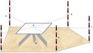
1. Radiation Method
The radiation method is the simplest method of plane table surveying. It is suitable when the entire survey can be carried out from a single station. In this method, all the points to be surveyed must be clearly visible from the selected station. The procedure of the radiation method is as follows:
- Select a station P such that all points A, B, C, D, and E are clearly visible from it.
- Perform centering, leveling, and orientation of the plane table.
- Place the alidade on point P and draw a line of sight toward station A.
- Measure the distance PA on the ground and plot it to a suitable scale on the paper.
- Repeat the same process for points B, C, D, and E by measuring distances PB, PC, PD, and PE.
- Join the plotted points a, b, c, d, and e to complete the plan.
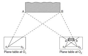
2. Intersection Method
In the radiation method, distances are measured directly on the ground. However, in hilly or rough terrain where direct measurement is difficult, the intersection method is preferred. The procedure of the intersection method is as follows:
- Select two stations, O1 and O2
- Measure and plot the baseline O1O2 to a suitable scale on the drawing sheet.
- From station O1, draw rays toward points A, B, etc.
- Shift the table to station O2, orient it by back sighting, and draw rays toward the same points.
- The intersection of the corresponding rays gives the plotted positions of points a, b, etc.
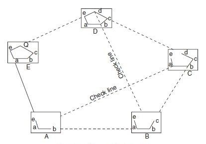
3. Traversing Method
The traversing method of plane table surveying is similar to compass surveying. It is used to run survey lines between stations whose positions are already fixed by other methods. This method helps in locating topographic details along the traverse.
- Fix the plane table at station A.
- Sight station B from A and measure the distance AB.
- Shift the table to station B and sight back to station A (back sighting).
- Plot the average of distances AB and BA to a suitable scale on the drawing sheet.
- From station B, sight station C and measure the distance.
- Repeat the process for all stations and carry out necessary checks at regular intervals.
4. Resection Method
The resection method is used to establish the position of a new survey station. It determines the plotted position of a ground station by taking sights toward known points whose positions are already plotted. This method is useful when the surveyor needs to locate missing details.
The resection method involves the following procedures:
- The three-point problem
- The two-point problem
Two-Point Problem
In the two-point problem, two well-defined points with known plotted positions are selected. These two points are joined on the drawing sheet, and the line is bisected accurately. The bisecting point represents the position of the new survey station.